Living in a big city can have its conveniences when running a quick errand or going out to a local restaurant, but what about when you need to get away from the hustle and bustle and enjoy a peaceful hike.
The Saint Louis area offers just that, which is why we’ve put together a list of 19 hikes near St. Louis, all within two hours of downtown, that will get you outside to enjoy the great outdoors. There are hiking trails for all skill levels, so let’s explore some of the best hikes in Missouri – and one in Illinois, of course.
Find one that best suits your abilities and say #hellotrail.
** We use the landmark of St. Louis City Hall in Downtown St. Louis when determining the estimated drive times.

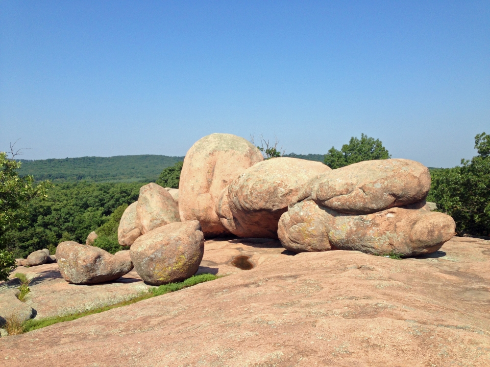
1. Braille Trail
Difficulty: Easy
Distance: 1 mile (1.6 km)
Trail Type: Loop
Location: Elephant Rocks State Park, Belleview, Missouri
Estimated Drive Time from STL: 1 hour and 30 minutes
The Braille Trail is one of the many kid friendly short hikes near St. Louis and a nice place to spend the day as a family. Located in Elephant Rock State Park, the Braille Trail was specifically designed for people with visual impairments and physical disabilities in 1981.
There are interpretive signs explaining the area’s history along the path, as well as wildlife and various plants in the park.
The giant granite boulders are another reason Braille trail is on our list. These rocks – known as nature’s circus elephants – began forming about 1.5 billion years ago. The history of how rocks are formed is so fascinating to us and hopefully you too!
2. Grant’s Trail
Difficulty: Easy
Distance: 10 miles one way (16 km)
Trail Type: Out and back
Location: Gravois Greenway Trailhead near Orlando’s (38.54219, -90.29919)
Estimated Drive Time from STL: 12 minutes
Grant’s Trail in Saint Louis is a paved path great for walking and biking that can be made as long or as short as you’d like. An excellent option for families and beginners, Grant’s Trail allows you to get outside to be active without having to drive too far from downtown.
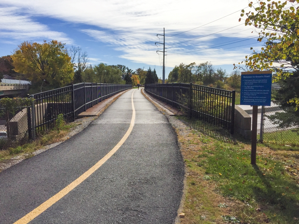
You can also break up your hike with a stop at Grant’s Farm that is along the trail, as well as parks and historical sites. Be sure to learn proper hiking etiquette when traveling on busier trails, keep to the right and be aware of bikes traveling on the path.
3. Quail Ridge Park Loop
Difficulty: Easy
Distance: 2.9 miles (4.6 km)
Trail Type: Loop
Location: Quail Ridge Park, 560 Interstate Drive, Wentzville, MO
Estimated Drive Time from STL: 40 minutes
Quail Ridge Park Loop is a paved trail less than an hour west of St Louis located around a 250-acre county park. The rolling hills offer a little challenge, but nothing too difficult, perfect for those just getting into hiking.
If you want to add distance, non-paved trails also meander through the trees. The loop trail at Quail Ridge Park offers frequent benches and easy access to restrooms.
4. Hawk Ridge Trail
Difficulty: Easy
Distance: 4.1 miles (6.6 km)
Trail Type: Loop
Location: Queeny Park near Chesterfield, Missouri
Estimated Drive Time from STL: 21 minutes
Hawk Ridge Trail is a family-friendly hike within an hour of St Louis, Missouri. The trail follows the perimeter of Queeny Park through woodlands and offers shaded sections, which is perfect for a hot summer day.
Although some wouldn’t consider this a hike, it allows anyone to get outside and be active if they can’t venture far from the city. The Hawk Ridge trail is primarily paved but does have a packed gravel section. Expect to see some wildlife, mostly deer and an array of birds.
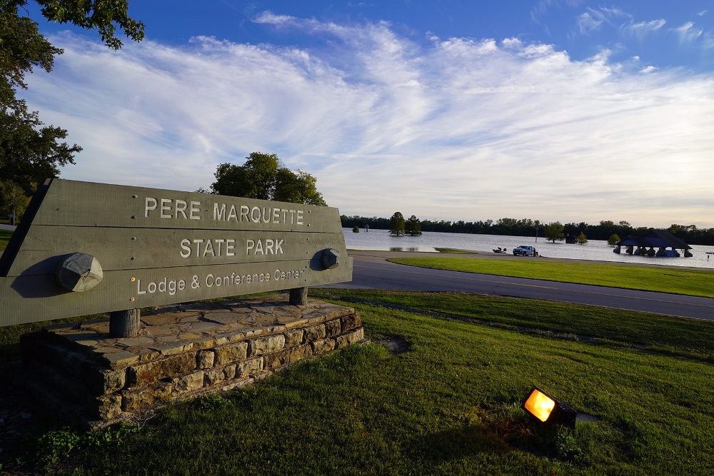
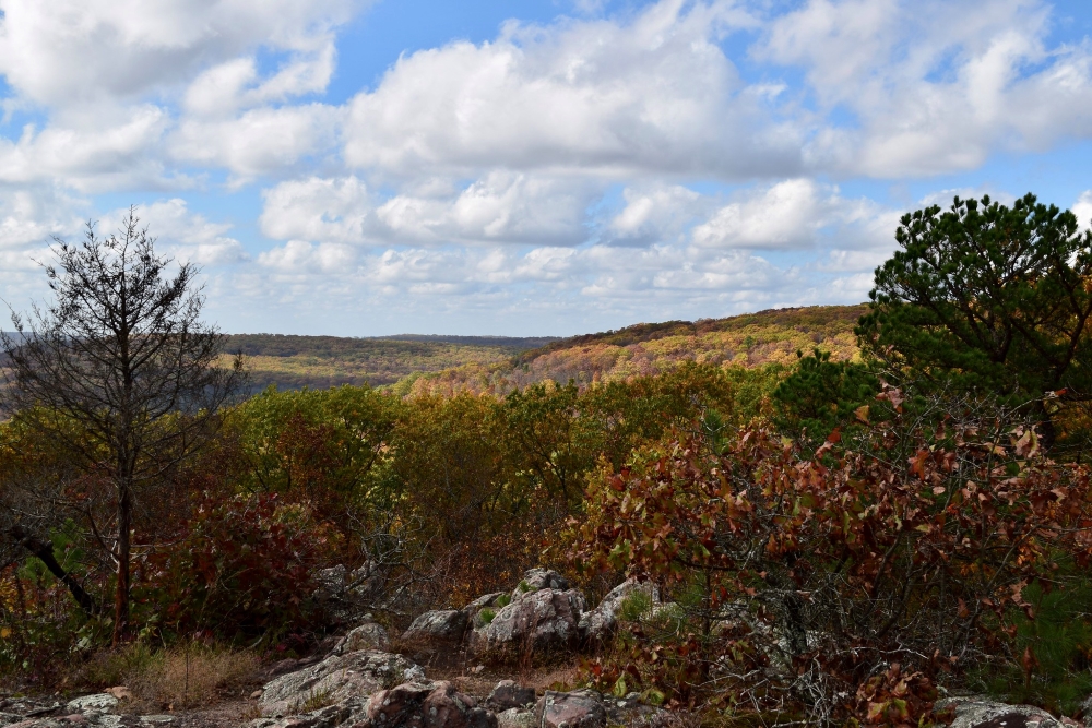
5. Pere Marquette State Park Outer Loop
Difficulty: Moderate
Distance: About 6 miles (9.6 km)
Trail Type: Loop
Location: Pere Marquette State Park, Grafton, Illinois
Estimated Drive Time from STL: 1 hour and 2 minutes
The St. Louis Metro Area Pere Marquette State Park Outer Loop is the only Illinois hike on our list. The Outer Loop – not the trail’s official name, combines numerous smaller connecting paths within the park.
Make sure to grab a trail map at the visitor center to guide you along, but it’s pretty easy to follow. Fellow hikers recommended traveling counterclockwise to see the best views and help even out the elevation gains (if you hike counterclockwise, you will end the hike with Goat Cliff Trail).
Expect great overlooks, one being of the Illinois River. When the leaves begin to change, Pere Marquette State Park is an ideal location to enjoy a fall hike in Illinois.
If you are hiking in the cooler months, chances are you will see a Bald Eagle in flight or hanging out on the ice along the Great River Road on your way to the park.
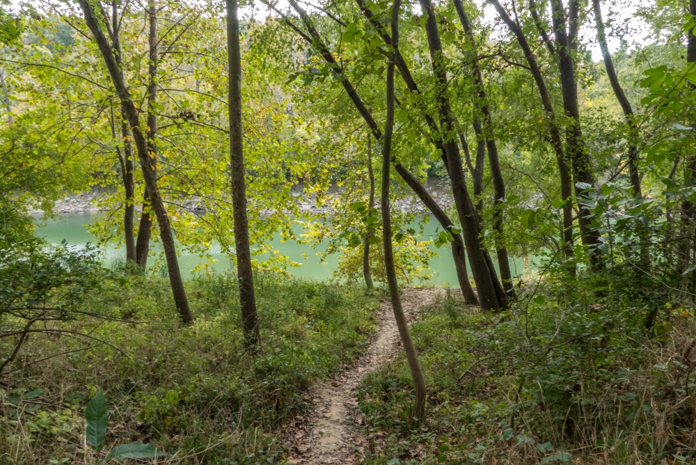
6. River Scene Trail
Difficulty: Moderate
Distance: 3.1 miles (5 km)
Trail Type: Loop
Location: Castlewood State Park, Ballwin, Missouri
Estimated Drive Time from STL: 32 minutes
The River Scene Trail hike is 30 minutes from St. Louis in Castlewood State Park. I would categorize it as moderately difficult because of the steep climb – 250 feet – right at the start as you travel counterclockwise.
Of course, you can go the opposite direction, but that requires climbing wooden stairs in the last half mile. Everyone has their personal preference and ours is usually to get the hard stuff out of the way first.
Elevation gain usually means picturesque views, so you have a chance to catch a breather at the different scenic overlooks that look down onto the Meramec River. The River Scene trail can get busy, so if possible, visit during a weekday or in the morning on the weekend.
7. Mina Sauk Falls Trail
Difficulty: Moderate
Distance: 2.9 miles (4.6 km)
Trail Type: Loop
Location: Taum Sauk Mountain State Park, Middle Brook, Missouri
Estimated Drive Time from STL: 1 hour and 45 minutes
If you are looking for waterfall hikes near St. Louis, then check out the Mina Sauk Falls trail. Even though the Mina Sauk Falls is a wet weather waterfall – which means the falls only flow after a recent rainstorm – it is still worth the effort!
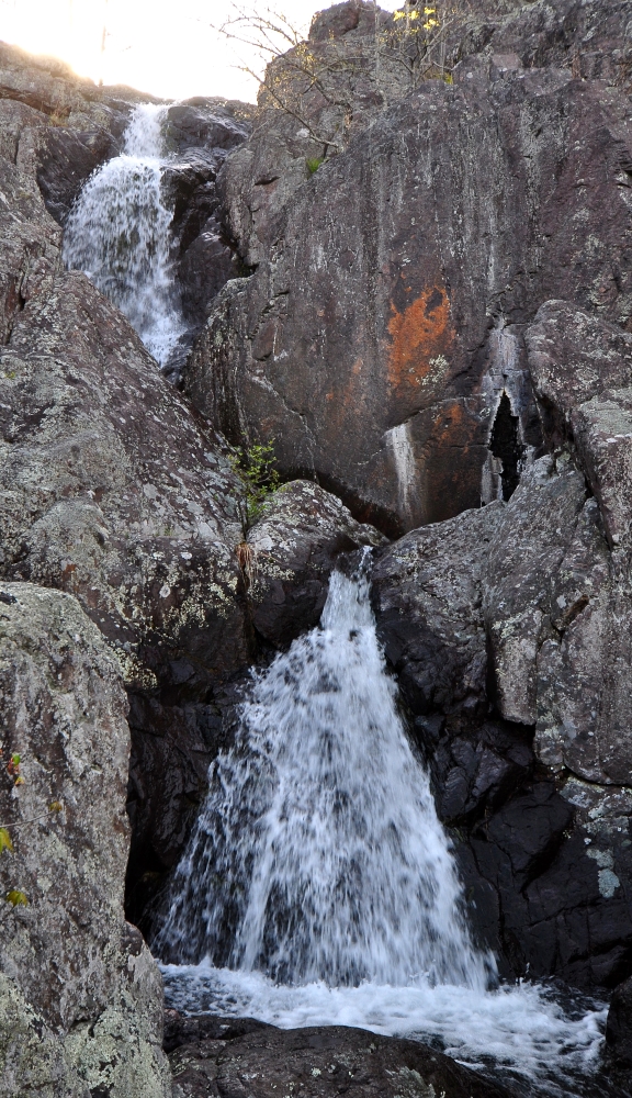
Mina Sauk Falls is the tallest waterfall in Missouri at 132 feet high. Not only will you get to see the highest waterfall in the state, but also stand on the tallest point in Missouri.
If you trek counterclockwise, you’ll descend 400 feet through the trees and make your way to the falls about halfway. To make a loop out of the trail, you can follow Taum Sauk Creek to ascend back to the trailhead. The first half of the hike is much rockier than the second half but worth the extra exertion.
8. Whispering Pines Trail
Difficulty: Difficult
Distance: 10.2 miles (16.4 km)
Trail Type: Multi-loop, separated between north and south
Location: Hawn State Park, Ste. Genevieve, Missouri
Estimated Drive Time from STL: 1 hour and 10 minutes
The Whispering Pines Trail in Hawn State Park is the longest St Louis area hike on our list. This trail gives you options, which we always like!
You can hike the north loop of the Whispering Pines Trail if you are looking for a shorter distance – about 6.2 miles. Or trek the multi-loop, which puts you around 10.2 miles.
The red arrows mark the north loop and blue arrows identify the south loop – the south loop is a little less maintained as it is less traveled. There are campsites along the trail, allowing you to break up the hike into a multi-day trip if you prefer, great for a short backpacking trip.
The Whispering Pines Trail has a little bit of everything for nature lovers – wildlife, creek crossings, tall pines, and rock formations. The hike can be strenuous since there is a bit of climbing, but the panoramic views make up for that.
9. Buford Mountain State Forest Trail
Difficulty: Difficult
Distance: 9.4 miles (15.1 km)
Trail Type: Loop
Location: Buford Mountain Conservation Area, Bismarck, Missouri
Estimated Drive Time from STL: 1 hour and 25 minutes
Buford Mountain State Forest Trail is one of the best hikes near St Louis with almost 2000 feet elevation gain. If you are up for a challenge and looking to strengthen your hiking endurance, the Buford Mountain State Forest Trail near Mark Twain National Forest fits the bill.
The first mile of the hike is the steepest, so your legs will warm up quickly! This climb also means you have a nice downhill at the end of your hike, which is always a plus.
You’ll have nice scenery along the way, but the best overlook on the Buford Mountain State Forest trail is at Bald Knob. Valleys, farm fields, woodlands… In my opinion, the awe inspiring views are what keep me going on a strenuous hike even when my legs are toast.
10. Fox Run Trail
Difficulty: Difficult
Distance: 10 miles (16 km)
Trail Type: Loop
Location: Rockwoods Range Conservation Area, Missouri (38.53029, -90.71761)
Estimated Drive Time from STL: 37 minutes
The Fox Run Trail is one of the must-do hiking trails in St. Louis. If you are looking for a good leg workout, it links up to Round House Loop trail in Rockwoods range to create a 10-mile loop with around 1300 feet in elevation gain.
The Fox Run Trail is not heavily trafficked, so if you are looking for a peaceful adventure in Missouri this is it!
A few things to keep in mind are there are no real views as the trees are pretty dense, it’s recommended to use trekking poles, and the trail can get pretty muddy, so be sure to wear a good pair of hiking boots.
Even though there aren’t any breathtaking views, you’ll come across wildflowers during the spring and summer. Look out for some of the stream crossings, but you’ll have no issues if you are wearing the right gear – ie: waterproof boots.
If you aren’t looking for a long-distance hike, make this trail shorter – about 7 miles round trip – by turning it into an out and back. Once you finish the Fox Run Trail section, turn around and do not complete the loop section.
11. Al Foster Trail
Difficulty: Easy
Distance: 2.5 miles one way (4 km)
Trail Type: Out and back
Location: Inside Sherman Beach Park (38.53565, -90.58845)
Estimated Drive Time from STL: 41 minutes
The Al Foster Trail is an easy trek that will take around 2.5 hours, but it has so much to offer! You’ll pass through old gravel quarries, sunken barges in the river, and have spectacular views of Palisade Bluffs along the way.
Whether you’re into birding, hiking, or mountain biking, this trail is perfect for you. And don’t forget about your four-legged friends, dogs are welcome too, as long as they’re kept on a leash.
Plus, there are plenty of other trails nearby if you’re looking for something more challenging.
12. Lewis & Clark Trail Loop
Difficulty: Moderate
Distance: 8 miles (12.9 km)
Trail Type: Loop
Location: Weldon Spring Conservation Area (38.69117, -90.72446)
Estimated Drive Time from STL: 35 minutes
The Lewis and Clark Trail Loop is an amazing way to explore the beauty of St. Louis, Missouri! It’s an 8-mile circular trail that takes you past stunning limestone cliffs and bluff escarpments with breathtaking views of the Missouri River.
No matter what time of year it is, this trail has something to offer, from hiking and running in the summer and fall to bird watching in the spring and winter.
A word of warning, though, some sections can get quite muddy, so be prepared for that. Luckily, dogs are allowed but must remain on a leash at all times. The best part of the whole experience is the first 2 miles, so I would highly recommend not skipping it.
13. Ozark Trail’s Taum Sauk Section
Difficulty: Difficult
Distance: 36 miles one way (58.9 kilometers)
Trail Type: Out and back
Location: Goes from Highway A trailhead (37.62587, -90.91101) to Highway 21 trailhead (37.54861, -90.6798)
Estimated Drive Time from STL: 1 hour and 50 minutes
Are you looking for an exciting and rewarding hiking experience? Look no further than the Taum Sauk Section of the Ozark Trail near Belleview, Missouri. This rugged 36-mile point-to-point trail traverses rivers, waterfalls and ancient mountains as you make your way along the rocky and sometimes poorly marked path.
This 15-hour trek is not for the faint of heart and requires proper gear and perseverance to complete it, especially when river crossings become challenging due to slippery conditions.
Bring a water filter with you as some sources may not be safe to drink from, and remember that ticks can be a problem. There have been car break-ins in the parking area, so don’t leave any valuables in plain sight.
Despite these potential challenges, you will be rewarded with stunning views of the Ozarks valleys and a sense of accomplishment after overcoming the obstacles on the trail.
14. Rock Quarry Trail
Difficulty: Moderate
Distance: 2.1 miles (3.4 km)
Trail Type: Loop
Location: Rockwoods Reservation (38.56530, -90.66812)
Estimated Drive Time from STL: 40 minutes
If you’re looking for a great trail to explore near St. Louis, the Rock Quarry Trail is an excellent choice! It’s a 2.1 mile loop that takes just under an hour to complete and offers breathtaking views of wildflowers, foliage, and interesting history from the 1850s.
It’s moderately challenging, with some steep and muddy spots, but overall it’s an easy hike with some elevation changes. And if you’re up for something longer, you can combine this trail with other offshoots in the area.
15. Green Rock Trail
Difficulty: Moderate
Distance: 8.3 miles roundtrip (13.4 km)
Trail Type: Out and back
Location: Rockwoods Reservation (38.56557, -90.66569)
Estimated Drive Time from STL: 36 minutes
The Green Rock Trail is a great choice if you’re looking for an adventurous hike! It’s 8.3 miles roundtrip, and it’ll take around 4 hours to complete. Be warned though, in parts it can be quite muddy and rocky with some elevation changes for a good workout.
The first half of the trail doesn’t offer much in terms of trees and wildlife, but the second half has more dense woods with a better maintained path. Plus, at the end of the trail, you get to experience the best view of the whole journey.
Just make sure to keep an eye out for the lack of clear markings in certain places since it could add extra time to your trip.
16. Lime Kiln Trail
Difficulty: Moderate
Distance: 2.9 miles (4.7 km)
Trail Type: Loop
Location: Rockwoods Reservation (38.55959, -90.65220)
Estimated Drive Time from STL: 35 minutes
The Lime Kiln Trail is a great choice for hikers, runners, and birdwatchers alike. Whether you’re looking for an easy day trip or a longer journey, this 2.9 mile loop will take you around 1 hour and 12 minutes to complete.
You’ll get to experience some stunning views of nature, as well as encounter wildflowers and wildlife during your outing. Plus, Rockwoods Reservation has plenty of other attractions like springs, caves, and rock formations that are sure to make the adventure even more exciting.
Just note that it can be pretty muddy in some spots, so wear appropriate footwear!
If you have a pup, they can join you on the trail too, just be sure to keep them on a leash. This popular trail tends to get crowded quickly, especially on weekends when the small parking lot fills up fast. So come early and enjoy the beauty of the Lime Kiln Trail while everyone else sleeps in!
17. Spring Valley Trail
Difficulty: Moderate
Distance: 3.4 miles (5.5 km)
Trail Type: Loop
Location: Cliff Cave County Park (39.01945, -90.40018)
Estimated Drive Time from STL: 55 minutes
If you’re looking for a great trail to explore near St. Louis, the Spring Valley Trail is definitely worth checking out! Not only does it offer stunning views of the river and wildlife, but the springtime wildflowers in bloom make this hike even more magical.
It takes around an hour and 12 minutes to complete the moderate 3.4 mile loop. Some parts may be muddy, but overall, it’s well-maintained and provides a peaceful escape into nature.
What more could you want? Plus, if you get tired, there’s even a cave you can rest in.
18. White Bison Trail Loop
Difficulty: Moderate
Distance: 3 miles (4.8 km)
Trail Type: Loop
Location: Lone Elk Park (39.15588, -90.41459)
Estimated Drive Time from STL: 1 hour
If you’re looking for a fun, moderately challenging hike near St. Louis, then look no further than the 4.8 km White Bison Trail Loop in Lone Elk Park! It’s perfect for hiking, running and walking, so you’ll encounter plenty of other people on the trail with you.
April through October is the best time to visit, but be aware that some parts of the trails may be muddy or slick. Just make sure to keep your distance from the elk during mating season and you should have an enjoyable and safe experience.
19. Rock Hollow Trail
Difficulty: Easy
Distance: 7 miles (11.4 km)
Trail Type: Out and back
Location: Rock Hollow Park (39.15588, -90.41459)
Estimated Drive Time from STL: 1 hour and 1 minute
The Rock Hollow Trail is a great choice for nature lovers who are looking to explore the outdoors. The 7 mile out-and-back path has plenty of scenic views and unique geological formations.
It’s an easy route that will typically take 2 hours and 24 minutes to complete, so it’s the perfect distance for a day hike that leaves plenty of time for other activities.
Plus, dogs are allowed as long as they’re leashed and there are also accessible parking spaces, benches, and restrooms should you need them.
What mountains are closest to St Louis?
The closest mountains to St Louis are the St. Francois Mountains two-hours south of the city. The St. Francois Mountain range consists of Taum Sauk mountain, which is the highest point in Missouri at an elevation of 1,772 ft, Bell Mountain, Buford Mountain, Proffit Mountain, Pilot Knob, Hughes Mountain, Goggin Mountain and Lead Hill Mountain.
Wrapping It Up…
As you can see, the St. Louis area has excellent hiking trail options within a 2-hour drive.
Whether you are looking for an easy paved park trail to take in the fresh air or a long, difficult hike that challenges your hiking skills, we hope these ten trails will help encourage you to get out and explore what the Midwest has to offer!
Don’t Miss:
Start planning ahead and check out these other great hiking areas:

Check out our Google Web Story – Explore These 7 Enchanting Hiking Trails Near St. Louis